First introduced in fall 2012 by French company Lehmann Aviation, the LA100 was the first completely automatic personal drone that could capture aerial footage via an onboard GoPro camera. The drone was able to fly along a predefined path, return to the launch point and land automatically. In 2013 the company expanded the L-A series UAVs with the professional LA200 and LA300 models which feature longer flight autonomy and WiFi connectivity. The company has released recently a revised version of the LA100 drone, adding a WiFi module to the entry-level model as well. An OperationCenter remote control app for Windows Phone 8 devices has also been released, which allows full control and setup of the LA100-version 2 drone.

All L-A series unmanned aerial systems (UAS) are designed to be extremely easy to use, no previous flight experience is necessary. Low-level aircraft control, including take-off and landing, is handled automatically and completely transparent by the on-board computer, leaving the user to focus on high level mission tasks like actual path creation, video or even terrain mapping.
Physical characteristics
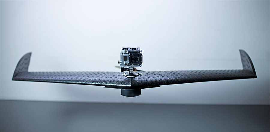
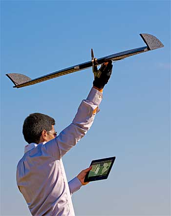
LA100 drone | Photo: Lehmann
The drones share similar exterior characteristics, they all have a 92 centimeter wingspan and are build using aluminium and carbon fiber composite materials, while most of the airframe is made up of foam, resulting in a very sturdy yet lightweight structure, that can also be easily serviced in case of damage.
The LA100 weights 850 grams, including one attached camera, while the LA200 and LA300 models have a similar weight of 950 grams. Mounts for different models of GoPro cameras are available either on top or on the belly of the aircraft, the drones can also be flown with 2 on board cameras, however flight range might be reduced. The LA300 top model can also carry a Nokia Lumia phone on its belly. A comparison of characteristics of the L-A drones is presented in the table below.
| LA100 | LA200 | LA300 | |
|---|---|---|---|
| Payloads | GoPro Hero all models Hero3 only on top mount | GoPro Hero all models | GoPro Hero3+ Nokia Lumia NIR sensor |
| Communication | Wi-Fi | Wi-Fi | Wi-Fi |
| Wingspan (cm) | 92 | 92 | 92 |
| Length (cm) | 45 | 45 | 45 |
| Weight (g) | 850 | 950 | 950 |
| Speed (km/h) | 20-80 | 20-80 | 20-80 |
| Altitude AGL (m) | 80-100 | 20-500 | 20-500 |
| Wind resistance (km/h / knots) | 35/20 | 35/20 | 35/20 |
| Range (km) | 0.5 | 3 | 15 |
| Autonomy (minutes) | 5 | 30 | 30 |
All drones are hand launched and can autonomously fly, return and land horizontally at the launching point or at other predefined locations — LA200 and LA300 only. OperationCenter software or app are used to send mission data to the drones and monitor flight parameters and progress, GPS sensors being used to acquire positioning data. Similarities between the LA drones end when it comes to purpose and functions, so let’s take a look at their functional properties.
Roles and functions
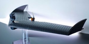
LA300 ready to launch | Photo: Lehmann
The LA100-version 2 drone is designed as a user-friendly personal drone for short range flights. It comes with a preset flight path and can be flown right out of the box, after installing your GoPro camera. As mentioned earlier the drone can be monitored in real time from the OperationCenter WP8 app, and different flight paths can be uploaded to the aircraft. Price for this model is less than 1000 US Dollars or Euro plus taxes, depending on region.
The LA200 model is very similar, the main difference being its augmented flight autonomy, thanks to the higher capacity battery pack. Advanced mission control and customization are available through the OperationCenter Windows 8 software. This drone can be bought at about 2500 US Dollars without taxes.
The advanced LA300 drone can accomplish long range missions and can also perform professional grade orthomosaicking and digital elevation modeling (DEM) terrain mapping tasks through the OperationCenter software. NIR (near infrared) sensors can also be mounted for short wave IR imaging. The LA300 can be bought for about 4000 US Dollars.
OperationCenter software
As mentioned earlier, the WP8 app fully supports LA100 and LA200 models, as well as most functions and monitoring of the LA300 drone. The more advanced OperationCenter 2.0 software is a complete drone management system which offers full control over the drone, flight planning and data logging and processing. The software is compatible with Windows 8 and WP8 OS environments.
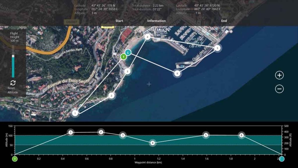
Orthomosaic and DEM
The software can perform ortho-mosaicking, which is a complex image processing technique comprised of ortho-rectification and mosaicking.
In the ortho-rectification phase of the process captured images are corrected for distortion caused by a combination of terrain geometry, image capture vantage point and of course the capturing device, i.e. camera, itself. Corrections are made based on elevation data, various camera and lens information and positioning.
In the second part of the process, the mosaicking phase, separate images are stitched together to form a single coherent image that accurately represents the terrain portion captured.
Terrain geometry can be represented using certain methods, one of them being DEM. In this case only actual ground surface is considered, without taking into account tall buildings, trees, and so forth. Mapping is accomplished by recording terrain in various spectral bands, one of them being short wave infrared radiaton (SWIR), captured using a NIR sensor, mentioned above.
A presentation video for the LA100-version 2 drone can be watched below.